115 years of sedimentation in the Urft Reservoir
Summary
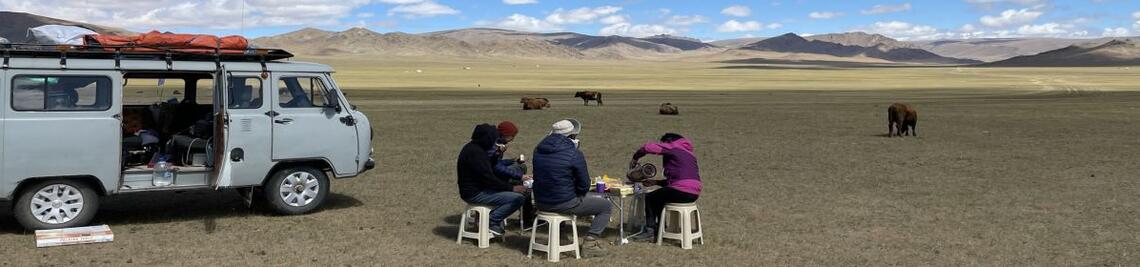
The sediments of Lake Urft represent a unique archive of human influence on the late Holocene sediment composition. The reason for this is that the sediments in the lake have been deposited almost undisturbed over the last 115 years. Due to construction work on the Urft dam and the inspection of the 2.7 km long Kermeter tunnel, which drives the Heimbach hydropower plant, the reservoir was almost completely drained in November 2020. This provided a rare opportunity to sample the deposits in detail and to photogrammetrically record the entire reservoir using an unnamed aircraft (also known colloquially as a drone, or UAS for Unoccupied Aircraft System). The work was carried out in collaboration with the Eifel Rur Water Board (WVER).

Humans have had a strong influence on landscape formation for thousands of years. Since the beginning of industrialisation and especially since the middle of the 20th century, this influence has increased significantly on a global scale. In the Anthropocene, humans have become the dominant shapers of the landscape. This is clearly manifested in its influence on the sediment cycle. While more intensive agriculture, deforestation and mining have led to an increase in sediment transport in rivers, the construction of reservoirs has resulted in a sediment deficit downstream. It is estimated that around 26 % of the global terrestrial sediment flux is retained in reservoirs.
At the same time, reservoirs form an excellent landscape archive due to their high accumulation rate and undisturbed sedimentation conditions. Many anthropogenically released pollutants, such as heavy metals, plastics or persistent organic pollutants (POPs), are stored in the sediments.
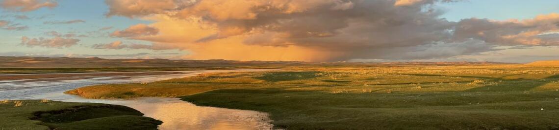
The Urft Reservoir is located in the northern Eifel at the transition to the Lower Rhine Bay. The reservoir has a volume of 45.5 million cubic metres and a length of 12 km. The main tributary is the river Urft, which gives the reservoir its name, with a catchment area of 372 km². The Urft dam was built between 1900 and 1905 and the resulting reservoir was the largest in Central Europe at the time. Its functions to this day are flood protection, supplying water to industry downstream during dry periods and power generation. Together with the Rurstausee and the Obersee, the region is also known as the Eifel lake district and is an important local recreation area. The reservoir was almost completely drained in 2020 for inspection work. In collaboration with the Eifel-Rur Water Association (WVER), the bottom of the reservoir was intensively surveyed and sampled in order to reconstruct the landscape history of the region over the last 115 years.

As part of the project, the deposits in the reservoir were analysed sedimentologically in detail. Geochemical markers were used to quantify the anthropogenic influence on the sediments in the form of mining-induced pollutant contamination (e.g. heavy metals) and to correlate this with the history of use in the catchment area. Another focus was on recording the microplastic and persitent organic pollutants (POP) content of the different sediment layers. As microplastics have only been introduced into the natural system by humans for the last 70 years since the start of mass production around 1950, the sediment layers can also be differentiated over time. The detection of microplastics in a sediment layer indicates deposition after 1950. In addition, the sediment depth can be applied to the reference period of 70 years and thus provides indications of a possible localised sedimentation rate. A total of seven sediment cores were taken from the deposits for these investigations.
Both detailed aerial maps and high-resolution terrain models are created from the aerial photographs. The terrain models in turn enable us to determine the sediment volume and the changed storage space of the dam in comparison with historical topographical images.
Publications
Stauch, G., Dörwald, L., Esch, A., Walk, J., 2025. Der Urftstausee – ein Archiv des Anthropozäns. In Würzburger Geographische Arbeiten, 128, Job, H.; Kempf, J.; Lang-Novikov, K.; Losang, E. (Hrsg.), S. 142–143. 2025.
Schwanen, C.A., Stauch, G., Schulte, P., Schwarzbauer, J., 2024. Reconstruction of the pollution history of the Urft reservoir: an organic-geochemical investigation. Environmental Sciences Europe 36, 103. https://doi.org/10.1186/s12302-024-00929-2
Stauch, G., Dörwald, L., Esch, A., Walk, J., 2024a. 115 years of sediment deposition in a reservoir in Central Europe: Topographic change detection. Earth Surface Processes and Landforms 49, 582–600. https://doi.org/10.1002/esp.5722
Stauch, G., Schulte, P., Schwanen, C., Kümmerle, E.A., Dörwald, L., Esch, A., Lehmkuhl, F., Walk, J., 2024b. 115 years of sediment deposition in a reservoir in Central Europe: Effects of the industrial history and environmental protection on heavy metals and microplastic. Earth Surface Processes and Landforms 49, 3419–3436. https://doi.org/10.1002/esp.5914
Stauch, G., Dörwald, L., Esch, A., Walk, J., 2023a. High-resolution digital surface models (DSMs) of the Urft River valley (Urft Reservoir) from 2020 and 2021, northern Eifel Mountains, western Germany. https://doi.org/10.18154/RWTH-2023-08809
Stauch, G., Dörwald, L., Esch, A., Walk, J., 2023b. High-resolution digital elevation model (DEM) of the Urft River valley (Urft Reservoir) from 1897, northern Eifel Mountains, western Germany. https://doi.org/10.18154/RWTH-2023-08808
Team
- PI:
Univ.-Prof. Dr. Georg Stauch (JMU)
A. Esch (WVER) - Sedimentology:
Dr. P. Schulte (PGG) - Mikroplastic:
C. Schwanen (EMR) -
Photgrammetry and digital surface models:
L. Dörwald (PGG)
Dr. J. Walk (JMU)
