The Geomorphology-Sandbox
The sandbox is used to simulate various geomorphological processes on a small scale. One focus of the simulations is on fluvial-geomorphological processes. For example, the causes and consequences of flood events can be visualised. As part of the experiments, various valley cross-sections are modelled and the resulting discharge and erosion processes are measured. Further variations are, for example, the integration of transverse structures in the river cross-section or the simulation of impervious surfaces.


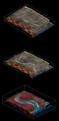
High-precision laser scans enable the creation of 3D models. Multi-temporal time slices of the geomorphological forms are used to calculate sediment balances. The digital models can be used to precisely determine local erosion and accumulation events.
The geomorphological sandbox thus makes it possible to prepare small-scale measurements that can later be carried out in the field, e.g. with a terrestrial laser scanner.