Univ.-Prof. Dr. Georg STAUCH

Tel.: +49 931 31-84714
E-Mail: georg.stauch@uni-wuerzburg.de
Institut für Geographie und Geologie
Lehrstuhl für Geomorphologie
Am Hubland
97074 Würzburg
Campus Hubland Süd
Geographiegebäude
Zimmer 227
nach Vereinbarung
115 Jahre Sedimentation in der Urftalsperre
Die Sedimente des Urftsee stellen ein einzigartiges Archiv für den Einfluss des Menschen auf die spätholozäne Sedimentzusammensetzung dar. Grund dafür ist, dass es in dem See in den letzten 115 Jahren zu einer fast ungestörten Ablagerung der Sedimente kam. Aufgrund von Bauarbeiten an der Urftstaumauer und der Inspektion des 2,7 km langen Kermeterstollen, über den das Wasserkraftwerk Heimbach angetrieben wird, wurde der Stausee im November 2020 fast vollständig abgelassen. Dies bot die seltene Gelegenheit die Ablagerungen detailliert zu beprobensowie den gesamten Stauraum mittels einem unbenanntem, umgangssprachlich meist als Drohne bezeichneten, Luftfahrzeug (auch UAS für Unmanned Aircraft System) photogrammetrisch zu erfassen. Die Arbeiten erfolgten in Zusammenarbeit mit dem Wasserverband Eifel Rur (WVER).
Charakterisierung von Oberflächen in Trockengebieten aus Sentinel-1 Radardaten
Die Trockengebiete der Erde waren und sind besonders anfällig für klimatische Änderungen. Gleichzeitig sind sie der Lebensraum für mehr als 2 Milliarden Menschen. Aufgrund der Größe der Räume, der in weiten Teilen schlechten infrastrukturellen Ausstattung und den häufig widrigen Umweltbedingungen weist der Forschungsstand zu den Raten der Landschaftsveränderungen noch große Lücken auf. Schon seit mehreren Jahrzehnten werden Fernerkundungsdaten intensiv zum Monitoring von Trockenräumen eingesetzt. Aber gerade in Bezug auf geomorphologischen Prozesse und Prozessraten stoßen optische Fernerkundungsmethoden häufig an ihre Grenzen. Im Rahmen dieses Projektes wird daher die Eignung von Radardaten zur Charakterisierung von Oberflächen untersucht.

Smartphone-gestützte Kartierung geomorphologischer Formen
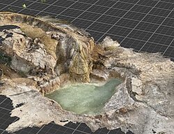
Das Verständnis der dreidimensionalen Eigenschaften von Objekten ist ein wesentlicher Bestandteil der Lehre in der Geomorphologie. Dieses lässt sich am besten bei Exkursionen im Gelände erreichen. Es gibt allerdings zahlreiche Gründe, warum eine Lehrveranstaltung im Gelände nicht möglich ist, entweder für eine Gruppe von Lernenden oder auch nur für einzelne. Statische oder interaktive 3D-Modelle von geomorphologischen Formen sind eine hervorragende Möglichkeit, das Verständnis der Lernenden substanziell, z. B. in einer Blended-Learning-Umgebung, zu verbessern. Die Erstellung von 3D-Modellen einzelner geomorphologischer Formen war jedoch bisher sehr zeitaufwändig. Seit 2020 sind in einigen neuen Smartphones LiDAR-Sensoren eingebaut. Diese Systeme ermöglichen eine einfache und kostengünstige Erfassung von geomorphologischen Formen und Objekten in drei Dimensionen. Sie eignen sich für die Erfassung von Objekten im Bereich von mehreren Dezimetern bis Metern. Insgesamt bieten diese Systeme ein großes Potential, da sie in der Lehre an Schulen und Universitäten das Verständnis der dreidimensionalen Struktur geomorphologischer Formen und Objekte unterstützen und somit den Lernerfolg bei Schülern und Studierenden erhöhen. Darüber hinaus bieten 3D-Modelle die Geomorphologie neue Möglichkeiten für Lernende, welche nicht in der Lage sind an Geländeexkursionen teilzunehmen. Gleichzeitig bieten sich in der Forschung neue Möglichkeiten für wissenschaftliche Untersuchungen, z.B. durch die kontinuierliche Beobachtung von geomorphologischen Veränderungen im Rahmen von Citizen Science Projekten.

GEO-XR: XR für geographische Raumanalysen
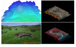
Das Projekt ist Teil der Förderinitiative „WUEDIVE – Digitale Innovation in der Lehre“ des Zentrums für wissenschaftliche Bildung und Lehre (ZBL) und wird sich mit den Möglichkeiten befassen Landschaftsentwicklungsprozesse, die oft viel zu langsam für die menschliche Wahrnehmung stattfinden (z.B. Bildung von Flussterrassen, Trockenfallen von Sumpflandschaften), mit Techniken der erweiterten Realität (VR und AR) im Zeitraffer und visuell ansprechend erlebbar zu machen.

Die Geomorphologie-Sandbox
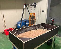
Mit der Sandbox werden verschiedenen geomorphologische Prozesse praktisch simuliert in kleinem Maßstab simuliert. Ein Schwerpunkt der Simulationen liegt hierbei auf fluvial-geomorphologischen Prozesse. So können z.B. die Ursachen und Folgen von Hochwasserereignissen anschaulich dargestellte werden.
Hochgenaue Laserscans ermöglichen die Erstellung von 3-D Modellen. Multi-temporale Zeitscheiben der geomorphologischen Formen werden zur Berechnung von Sedimentbilanzen genutzt. Über die digitalen Modelle können genau Bestimmungen der lokalen Erosions- und Akkumulationsereignisse durchgeführt werden.
-
Dynamics of dunes and climate variability over the last five decades: A remote sensing analysis of regional contrasts on the northeastern Tibetan Plateau and the adjacent Hexi Corridor. . In Global and Planetary Change, 252, S. 104873. Elsevier BV, 2025.
-
Drivers of late Quaternary lake level fluctuations of Khyargas Nuur, western Mongolia - glacial meltwater discharge or atmospheric moisture supply?. . In Quaternary Science Reviews, 359, S. 109373. 2025.
-
Late Quaternary geomorphological processes and landscape evolution in the Khur Basin, central Iran. . In E&G Quaternary Science Journal, 74(2), S. 193–212. 2025.
-
Der Urftstausee – ein Archiv des Anthropozäns. . In Würzburger Geographische Arbeiten, 128, H. Job; J. Kempf; K. Lang-Novikov; E. Losang (Hrsg.), S. 142–143. 2025.
- [ Abstract ]
-
115 years of sediment deposition in a reservoir in Central Europe: Effects of the industrial history and environmental protection on heavy metals and microplastic. . In Earth Surface Processes and Landforms, 49(11), S. 3419–3436. Wiley, 2024.
-
Reconstruction of the pollution history of the Urft reservoir: an organic-geochemical investigation. . In Environmental Sciences Europe, 36(1). Springer Science and Business Media LLC, 2024.
-
Opportunities for international cooperation in the field of Disaster Risk and Resilience Research. . 2024.
-
115 years of sediment deposition in a reservoir in Central Europe: Topographic change detection. . In Earth Surface Processes and Landforms, 49(2), S. 582–600. 2024.
-
Dune behavior in the Source Area of the Yellow River under climate changes observed from various remote sensing datasets. . In Aeolian Research, 67-69, S. 100928. 2024.
-
Angewandte Fernerkundung mit der Google Earth Engine. . S. III, 120 S. : Illustrationen, Tabellen, Diagramme. Geographisches Institut der RWTH Aachen, Aachen, 2024.
- [ DOI ]
-
Fernerkundung und Cloud-Computing – Eine kurze Einführung. . In Angewandte Fernerkundung mit der Google Earth Engine / mit Beiträgen von: Eileen Berg [und 7 anderen] ; Hrsg.: Georg Stauch, S. 1–7. Geographisches Institut der RWTH Aachen, Aachen, 2024.
- [ DOI ]
-
Dormant dune fields and ameliorative moisture conditions in the West Gobi Desert in East Asia during the Last Interglacial. . In Palaeogeography, Palaeoclimatology, Palaeoecology, 643, S. 112170. 2024.
-
High-resolution digital surface models ({DSM}s) of the Urft River valley (Urft {R}eservoir) from 2020 and 2021, northern Eifel Mountains, western Germany. . 2023.
-
Anthropogenic influence of open pit mining on river floods, an example of the Blessem flood 2021. . In Geomorphology, 421, S. 108522-. 2023.
-
Dune movement under climatic changes on the north-eastern Tibetan Plateau as recorded by long-term satellite observation versus ERA-5 reanalysis. . In Earth Surface Processes and Landforms, 48(13), S. 2613–2629. 2023.
-
Pedogenesis at the coastal arid-hyperarid transition deduced from a Late Quaternary chronosequence at Paposo, Atacama Desert. . In CATENA, 228, S. 107171-. 2023.
-
High-resolution digital elevation model ({DEM}) of the Urft River valley (Urft {R}eservoir) from 1897, northern Eifel Mountains, western Germany. . 2023.
-
Weathering under coastal hyperaridity – Late Quaternary development of spectral, textural, and gravelometric alluvial fan surface characteristics. . In Quaternary Science Reviews, 277, S. 107339-. 2022.
-
Late Quaternary landscape evolution and paleoenvironmental implications from multiple geomorphic dryland systems, Orog Nuur Basin, Mongolia. . In Earth Surface Processes and Landforms, 47(1), S. 275–297. 2022.
-
Smartphone-supported mapping of landforms – A new tool in teaching geomorphology. . In Erdkunde, 76(3), S. 227–234. 2022.
-
Beispiele für morphodynamische Prozesse und Verlagerungen in Folge des Hochflutereignisses 2021 im Ahrtal. . In Wasser und Abfall, 24(11), S. 40–47. 2022.
- [ DOI ]
-
Why analysing microplastics in floodplains matters: application in a sedimentary context. . In Environmental Science: Processes & Impacts, 23(1), S. 117–131. 2021.
-
The Way of Macroplastic through the Environment. . In Environments, 7(10), S. 73-. 2020.
-
Gradients in climate, geology, and topography affecting coastal alluvial fan morphodynamics in hyperarid regions – The Atacama perspective. . In Global and Planetary Change, 185, S. 102994-. 2020.
-
Morphotectonics of the northern Bogd fault and implications for Middle Pleistocene to modern uplift rates in southern Mongolia. . In Geomorphology, 367, S. 107330-. 2020.
-
Testing the potential of K-feldspar pIR-IRSL and quartz ESR for dating coastal alluvial fan complexes in arid environments. . In Electron spin resonance (ESR) dating in Quaternary studies: evolution, recent advances and applications, 556, S. 124–143. 2020.
-
Late Pleistocene alluvial fan evolution along the coastal Atacama Desert (N Chile). . In Global and Planetary Change, 190, S. 103091-. 2020.
-
Regional study of microplastics in surface waters and deep sea sediments south of the Algarve Coast. . In Regional Studies in Marine Science, 40, S. 101488-. 2020.
-
The way of microplastic through the environment – Application of the source-pathway-receptor model (review). . In Science of The Total Environment, 713, S. 136584-. 2020.
-
Canola Oil Extraction in Conjunction with a Plastic Free Separation Unit Optimises Microplastics Monitoring in Water and Sediment. . In Analytical Methods. 2020.
-
Surface Roughness Estimation in the Orog Nuur Basin (Southern Mongolia) Using Sentinel-1 SAR Time Series and Ground-Based Photogrammetry. . In Remote Sensing, 12(19), S. 3200-. 2020.
-
Oil Extraction as Separation Method for Microplastic in Sediment Samples. . M. Cocca, E. Di Pace, M. E. Errico, G. Gentile, A. Montarsolo, R. Mossotti, M. Avella (Hrsg.), S. 282–286. Springer International Publishing, 2020.
- [ Abstract ]
-
Late Quaternary environments in the Gobi Desert of Mongolia: Vegetation, hydrological, and palaeoclimate evolution. . In Palaeogeography, Palaeoclimatology, Palaeoecology, 514, S. 77–91. Elsevier BV, 2019.
- [ DOI ]
-
A conceptual model for the interpretation of aeolian sediments from a semiarid high-mountain environment since the late glacial. . In Quaternary Research, 91(1), S. 24–34. Cambridge University Press, 2019.
-
Geomorphology of the coastal alluvial fan complex Guanillos, northern Chile. . In Journal of Maps, 15(2), S. 436–447. 2019.
-
Response of lake-catchment processes to Holocene climate variability: Evidences from the NE Tibetan Plateau. . In Quaternary Science Reviews, 201, S. 261–279. Elsevier BV, 2018.
- [ DOI ]
-
Environmental changes during the late Pleistocene and the Holocene in the Gonghe Basin, north-eastern Tibetan Plateau. . In Palaeogeography, Palaeoclimatology, Palaeoecology, 509, S. 144–155. Elsevier BV, 2018.
- [ DOI ]
-
Paleolakes in the Gobi region of southern Mongolia. . In Quaternary Science Reviews, 179, S. 1–23. Elsevier BV, 2018.
- [ DOI ]
-
Geochemical imprints of coupled paleoenvironmental and provenance change in the lacustrine sequence of Orog Nuur, Gobi Desert of Mongolia. . In Journal of Paleolimnology, 58(4), S. 511–532. 2017.
-
Project house water: a novel interdisciplinary framework to assess the environmental and socioeconomic consequences of flood-related impacts. . In Environmental Sciences Europe, 29(1). Springer Science and Business Media LLC, 2017.
- [ DOI ]
-
Landscape and climate on the northern Tibetan Plateau during the late Quaternary. . In Geomorphology, 286, S. 78–92. Elsevier BV, 2017.
- [ DOI ]
-
Late Pleistocene glaciations at Lake Donggi Cona, eastern Kunlun Shan (
NE Tibet): early maxima and a diminishing trend of glaciation during the last glacial cycle.. . In Boreas, 46(3), S. 503–524. Wiley, 2017.- [ DOI ]
-
Aeolian sediments on the northern Tibetan Plateau. . G. Stauch (Hrsg.). 2017.
- [ DOI ]
-
Multi-decadal periods of enhanced aeolian activity on the north-eastern Tibet Plateau during the last 2ka. . In Quaternary Science Reviews, 149, S. 91–101. Elsevier BV, 2016.
- [ DOI ]
-
A persistent northern boundary of Indian Summer Monsoon precipitation over Central Asia during the Holocene. . In Scientific Reports, 6(1), S. 25791. 2016.
-
Discriminating sediment archives and sedimentary processes in the arid endorheic Ejina Basin, NW China using a robust geochemical approach. . In Journal of Asian Earth Sciences, 119, S. 128–144. Elsevier BV, 2016.
- [ DOI ]
-
Spatio-temporal pattern of detrital clay-mineral supply to a lake system on the north-eastern Tibetan Plateau, and its relationship to late Quaternary paleoenvironmental changes. . In CATENA, 137, S. 203–218. Elsevier BV, 2016.
- [ DOI ]
-
Influence of HCl pretreatment and organo-mineral complexes on laser diffraction measurement of loess–paleosol-sequences. . In CATENA, 137, S. 392–405. Elsevier BV, 2016.
- [ DOI ]
-
Late Quaternary Lake Dynamics in the Verkhoyansk Mountains of Eastern Siberia: Implications for Climate and Glaciation History. . In Polarforschung. Alfred-Wegener-Institut für Polar- und Meeresforschung und Deutsche Gesellschaft für Polarforschung, 2016.
- [ DOI ]
-
Late Quaternary aeolian sand deposition sustained by fluvial reworking and sediment supply in the Hexi Corridor — An example from northern Chinese drylands. . In Geomorphology, 250, S. 113–127. Elsevier BV, 2015.
-
Geomorphological and palaeoclimate dynamics recorded by the formation of aeolian archives on the Tibetan Plateau. . In Earth-Science Reviews, 150, S. 393–408. Elsevier BV, 2015.
-
Seismites as indicators for Holocene seismicity in the northeastern Ejina Basin, Inner Mongolia. . In Geological Society, London, Special Publications, 432(1), S. 213–231. Geological Society of London, 2015.
- [ DOI ]
-
Unmixed loess grain size populations along the northern Qilian Shan (China): Relationships between geomorphologic, sedimentologic and climatic controls. . In Quaternary International, 372, S. 151–166. Elsevier BV, 2015.
- [ DOI ]
-
Late Quaternary aeolian sand deposition sustained by fluvial reworking and sediment supply in the Hexi Corridor — An example from northern Chinese drylands. . In Geomorphology, 250, S. 113–127. 2015.
-
Timing and spatial distribution of loess and loess-like sediments in the mountain areas of the northeastern Tibetan Plateau. . In CATENA, 117, S. 23–33. Elsevier BV, 2014.
- [ DOI ]
-
Regional grain size variations in aeolian sediments along the transition between Tibetan highlands and north‐western Chinese deserts – the influence of geomorphological settings on aeolian transport pathways. . In Earth Surface Processes and Landforms, 39(14), S. 1960–1978. Wiley, 2014.
-
Interaction of geomorphological processes on the north-eastern Tibetan Plateau during the Holocene, an example from a sub-catchment of Lake Donggi Cona. . In Geomorphology, 210, S. 23–35. Elsevier BV, 2014.
-
Early to mid-Holocene lake high-stand sediments at Lake Donggi Cona, northeastern Tibetan Plateau, China. . In Quaternary Research, 79(3), S. 325–336. Cambridge University Press, 2013.
-
Characterisation of transport processes and sedimentary deposits by statistical end-member mixing analysis of terrestrial sediments in the Donggi Cona lake catchment, NE Tibetan Plateau. . In Sedimentary Geology, 281, S. 166–179. Elsevier BV, 2012.
-
Aeolian sediments on the north-eastern Tibetan Plateau. . In Quaternary Science Reviews, 57, S. 71–84. Elsevier BV, 2012.
-
Dry periods on the NE Tibetan Plateau during the late Quaternary. . In Palaeogeography, Palaeoclimatology, Palaeoecology, 346–347, S. 108–119. Elsevier BV, 2012.
-
Late Glacial and Holocene development of Lake Donggi Cona, north-eastern Tibetan Plateau, inferred from sedimentological analysis. . In Palaeogeography, Palaeoclimatology, Palaeoecology, 337–338, S. 159–176. Elsevier BV, 2012.
-
Environmental conditions in the Donggi Cona lake catchment, NE Tibetan Plateau, based on factor analysis of geochemical data. . In Journal of Asian Earth Sciences, 44, S. 176–188. Elsevier BV, 2012.
-
An end-member algorithm for deciphering modern detrital processes from lake sediments of Lake Donggi Cona, NE Tibetan Plateau, China. . In Sedimentary Geology, 243–244, S. 169–180. Elsevier BV, 2012.
-
Global, regional and local scale factors determining glaciation extent in Eastern Siberia over the last 140,000 years. . In Quaternary Science Reviews, 30(7–8), S. 821–831. Elsevier BV, 2011.
-
Basin morphology and seismic stratigraphy of Lake Donggi Cona, north-eastern Tibetan Plateau, China. . In Quaternary International, 218(1–2), S. 131–142. Elsevier BV, 2010.
-
Quaternary glaciations in the Verkhoyansk Mountains, Northeast Siberia. . In Quaternary Research, 74(1), S. 145–155. Cambridge University Press, 2010.
-
Late Quaternary glaciations in northeastern Russia. . In Journal of Quaternary Science, 23(6–7), S. 545–558. Wiley, 2008.
-
Sediment provenance of late Quaternary morainic, fluvial and loess‐like deposits in the southwestern Verkhoyansk Mountains (eastern Siberia) and implications for regional palaeoenvironmental reconstructions. . In Geological Journal, 42(5), S. 477–497. Wiley, 2007.
-
Luminescence chronology from the Verkhoyansk Mountains (North-Eastern Siberia). . In Quaternary Geochronology, 2(1–4), S. 255–259. Elsevier BV, 2007.
-
Jungquartäre Landschaftsentwicklung im Werchojansker Gebirge, Nordost Sibirien: mit 17 Tabellen. . S. V, 176 S. : Ill., graph. Darst., Kt. Geograph. Inst. der RWTH Aachen im Selbstverl., Aachen, 2006.
-
Geomorphologische Formungs-und Prozessregionen in Zentralasien. . In Petermanns Geographische Mitteilungen, 5, S. 6–13. 2003.
- [ Abstract ]
seit 2024 Inhaber des Lehrstuhl für Geomorphologie an der JMU Würzburg
2023
Außerplanmäßiger Professor an der RWTH Aachen
2017
Habilitation: "Aeolian sediments on the northern Tibetan Plateau", Thema des Habilitationsvortrages: Geomorphologische Prozesse auf dem Mars
2007
Promotion: "Jungquartäre Landschaftsentwicklung im Werchojansker Gebirge, Nordost Sibirien", RWTH Aachen
2002
Diplom: "Glazial-geomorphologische Kartierung im Russisch-Mongolischen Altai unter Verwendung von Satellitenbilddaten (Landsat ETM7), GIS, Luftbildern und eigenen Geländebefunden."
1996 – 2002
Studium: Geographie, Bioklimatologie und Botanik, Universität Göttingen und University of Exeter (UK)
- 2007 Friedrich-Wilhelm-Preis der RWTH Aachen
- 2008 Borchers-Plakette der RWTH Aachen
- 2012 Lehrpreis der Fachschaft Geographie der RWTH Aachen
- 2013 Auszeichnung als RWTH Lecturer für hervorragende Lehre und Forschungstätigkeit
- 2013 Lehrpreis der Fachschaft Geographie der RWTH Aachen
- 2016 Lehrpreis der Fachschaft Geographie der RWTH Aachen
- 2019 Lehrpreis der Fachschaft Geographie der RWTH Aachen
- 2019 Lehrpreis der Fakultät für Georessourcen und Materialtechnik für die beispielhafte Implementierung moderner und anschaulicher Lehrmethoden
- 2020 Lehrpreis der Fachschaft Geographie der RWTH Aachen
- 2021 Lehrpreis der Fachschaft Geographie der RWTH Aachen
- 2022 Lehrpreis der Fachschaft Geographie der RWTH Aachen
- 2023 Lehrpreis der Fachschaft Geographie der RWTH Aachen
- 2024 Ultimative Lehrpreis der Fachschaft Geographie der RWTH Aachen
- Geomorphologie
- Paläoklimatologie
- Klimawandel


